Hows that ride looking today? 80 degrees last week, 2 inchs of snow at least yesterday.
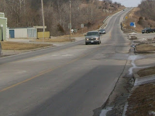
Sunday, March 29, 2009


Thursday, March 26, 2009
Brevet Schmevet it's Freedom Baby!
Looks like Saturday is out, so Sunday Me, Crusty and whom ever (Lewis) decides to join us are going to Gunn City. High Noon! If this place doesn't sound like the perfect place for you to ride through with pink, assless chaps (redundent . . . all chaps are assless right?)


Why Gunn City? . . . Because it's called Gunn City, and most of all these people have a low tolerance for B.S. I mean if part of your city's slogan is " death to tyrants". Then your going to get my interest. So will a 75 miles.
-
For a brief description visit here
http://www.casscounty.com/gunncity.htm
http://www.casscounty.com/gunncity.htm
For a more detailed description visit her
-
Basically the chairman of the county court, attorney for the local Railroad Company, and a couple others tried to rip off the citizens of Cass County. Which is important to note since Gunn City wasn't an official City until after the Masacre. If hyper links don't appeal to you, and you just want the blood and guts of it all . . . here you go.
-
1872 (April 24)
The malefactors were exposed and indicted. As they awaited their trial, scheduled for May 6, 1872, they became frightened by local residents' growing anger at their corruption.
The malefactors were exposed and indicted. As they awaited their trial, scheduled for May 6, 1872, they became frightened by local residents' growing anger at their corruption.
-
1). J. C. Stephenson, chairman of the county court
2). J. P. Cline, attorney for the Railroad Company
3). T. E. Dutroe
1). J. C. Stephenson, chairman of the county court
2). J. P. Cline, attorney for the Railroad Company
3). T. E. Dutroe
-
a Harrisonville Councilman who had signed their bail bonds, decided to escape by the eastbound train on the Missouri, Kansas & Texas Railroad on the evening of April 24, 1872. Twelve miles outside Harrisonville, near Gunn City (formerly Bryson), the train ground to a halt before a crude barricade. At least fifty Cass County men began firing at the train. "Turn out the bond thieves," raged the crowd.
a Harrisonville Councilman who had signed their bail bonds, decided to escape by the eastbound train on the Missouri, Kansas & Texas Railroad on the evening of April 24, 1872. Twelve miles outside Harrisonville, near Gunn City (formerly Bryson), the train ground to a halt before a crude barricade. At least fifty Cass County men began firing at the train. "Turn out the bond thieves," raged the crowd.

-
J. C. Stephenson was dragged from the train. They fired more than forty bullets into him and "vented their fiendish fury" according to the Kansas City Times.
J. C. Stephenson was dragged from the train. They fired more than forty bullets into him and "vented their fiendish fury" according to the Kansas City Times.
-
J. P. Cline drew a revolver and fired several shots into the crowd, wounding two men. Then jumping from the cars, he attempted to escape but fell. Three bullets pierced him, one passing through the head. Stephenson was killed in the baggage car. A shot severed both jugular veins and a blow from some sharp instrument split his skull nearly to the eyebrow. He died immediately.
J. P. Cline drew a revolver and fired several shots into the crowd, wounding two men. Then jumping from the cars, he attempted to escape but fell. Three bullets pierced him, one passing through the head. Stephenson was killed in the baggage car. A shot severed both jugular veins and a blow from some sharp instrument split his skull nearly to the eyebrow. He died immediately.
-
T. E. Dutroe was shot in the back of the head, the ball lodging over the left eye. He died in about four hours. It is not believed that Dutroe was one of the conspirators, but was killed because of his intimate association with them, after the crime was divulged.
T. E. Dutroe was shot in the back of the head, the ball lodging over the left eye. He died in about four hours. It is not believed that Dutroe was one of the conspirators, but was killed because of his intimate association with them, after the crime was divulged.
-
The mob swelled to two hundred as its members continued to batter the corpses with bullets in "one of the most terrible and atrocious massacres of the nineteenth century." Passengers recognized twenty of the mob before they rode off.
The mob swelled to two hundred as its members continued to batter the corpses with bullets in "one of the most terrible and atrocious massacres of the nineteenth century." Passengers recognized twenty of the mob before they rode off.
-
The mob achieved its purpose: its members had recovered $174,000 of the bonds that the ring had not yet sold, thus saving taxpayers from having to pay for that portion.
-
The mob achieved its purpose: its members had recovered $174,000 of the bonds that the ring had not yet sold, thus saving taxpayers from having to pay for that portion.
-
Special investigators John F. Philips and F. M. Cockrell . . .
(The name Cockrell should ring a few bells in the heads of people who frequent 350 highway between Blue Spring and Warrensberg)
http://cockrellmercantile.com/
http://cockrellmercantile.com/
-
. . . reported to Governor Brown that the best way to prevent vigilantes from unleashing "a forward military movement and a new carnival of blood" was not to prosecute them, but instead to "open to them the ways of peace, and return to their homes the fugitives…"
Nolle Prosequi
Nolle Prosequi
-
Forty-four men, including some of the most prominent, were indicted for the killing; twenty-nine were brought to trial; a nolle prosequi (is a Latin legal phrase meaning "not to pursue.") was entered in several cases, and all others were acquitted. Several of the indicted men were sued for damages by the families of those killed, but the suits were finally dismissed.
Forty-four men, including some of the most prominent, were indicted for the killing; twenty-nine were brought to trial; a nolle prosequi (is a Latin legal phrase meaning "not to pursue.") was entered in several cases, and all others were acquitted. Several of the indicted men were sued for damages by the families of those killed, but the suits were finally dismissed.
-
In suits brought for the recovery of the bonds, the conspiracy was made plain:
J.C. Cline $50,000 or $55,000,
R.S. Stevens received $35,000,
Stephenson or his son $12,000,
Higgins' share was about $3,000.
In suits brought for the recovery of the bonds, the conspiracy was made plain:
J.C. Cline $50,000 or $55,000,
R.S. Stevens received $35,000,
Stephenson or his son $12,000,
Higgins' share was about $3,000.
-
For Missouri public officials who violated local opinion, the message from Gunn City was more urgent. All but two of the "bloody bonds" were ordered to be destroyed. The two remaining bonds were framed and still hang today in the Gunn City Hall and the Cass County Clerk's office with this reminder inscription to local officials:
For Missouri public officials who violated local opinion, the message from Gunn City was more urgent. All but two of the "bloody bonds" were ordered to be destroyed. The two remaining bonds were framed and still hang today in the Gunn City Hall and the Cass County Clerk's office with this reminder inscription to local officials:
-
"This bond is to be framed and preserved in a public hall, that the public servants of Cass County may remember when they trample upon the rights of the people and refuse to hear their prayers, that they will appeal to a higher power and serve an injunction that will stick--which means death to tyrants."

"This bond is to be framed and preserved in a public hall, that the public servants of Cass County may remember when they trample upon the rights of the people and refuse to hear their prayers, that they will appeal to a higher power and serve an injunction that will stick--which means death to tyrants."

. . .
Now parallel the people of 1870's Cass County, with the people of today. If those people had big screen TV, Play Station, and cell phones that make blueberry pancakes like we have now, I wonder if those people would have gotten away?
. . .
M. K. Zook built the first house in the town in the winter of 1871, for a store, general merchandise. WHy is this important? Because we will be riding down Zook street to get through Gunn City.
-
May 9th, 1872 (2 weeks after the massacre) the town was laid out and named after O. B. Gunn, one time chief engineer of M. K. & T. R. R. . . . Coinsidence?
-
Exiting Gunn City we will be taking Old Drum Road and Old Drum Bridge . . . . Old Drum? . . . Yep, I got the answer for that, What, or Who is Old Drum?
http://www.warrensburg.org/drum.htm
http://www.warrensburg.org/drum.htm
-
The carcass of Old Drum is still buried at the corner of Old Drum Rd. and E. 239th St.
The carcass of Old Drum is still buried at the corner of Old Drum Rd. and E. 239th St.
Old Drum Road Bridge
-
Also we will cross J.W. Cummins Road Bridge
http://bridgehunter.com/mo/jackson/cummins-road/
http://bridgehunter.com/mo/jackson/cummins-road/
Thursday, March 19, 2009
The figures and the stats

(Click on Pictures to enlarge)
First off the 200k brevet is not 124.25 miles, but instead a little over at 130 miles. I was planning on riding my fixie, but what gear? I made this spread sheet where I can input the numbers in blue to find out my ride time, MPH, and other tid bits. The red text is for convenience store stops, which happen to be check points. Also I have list the check point opening times . . . don't want to be too early. Then it occured to me, maybe 130 on a fixed gear in March might be a bit much, so why not break out the 3 Speed Psycho-Cross. According to Sturmey Archer 1st gear advances 133%, and 3rd retards at 75%, so I also included those to see what the 2 other gears would be equivolent to.
-
For example if I change 43 to 40 (or any number in Blue or Red)you see that change reflected in all the figures.

I suspect I'll make changes, but I think it's pretty good so far. Who doesn't like statistics.
Sunday, March 15, 2009
So many towns, so little time
I'm beginning to think that the majority small towns around here have not changed since the 1870's. Take Freeman, Missouri for example. If you go to their "Downtown". This is what you will see.


In two weeks is the 200k Brevet (200 kilometers=124 miles). The big question is, to do it with gears, or fixed gear. The only Problem is the Super Bee only has one cage, but like the 108mile ride I just rode, I'll probably use a camel back. I don't mind it because I'm used to it from doing MTB events. This just might be a reason to build another frame . . . . Hmmmmmmmm.


In two weeks is the 200k Brevet (200 kilometers=124 miles). The big question is, to do it with gears, or fixed gear. The only Problem is the Super Bee only has one cage, but like the 108mile ride I just rode, I'll probably use a camel back. I don't mind it because I'm used to it from doing MTB events. This just might be a reason to build another frame . . . . Hmmmmmmmm.
Friday, March 6, 2009
Mad Ride Report
Mile 0 – 8:10am
Raytown (Pop: 30,388)
Benetti’s Coffee Shop
I’ve decided to start at Benetti’s coffee shop in Raytown. It’s good to start a long ride with a "Cup of Joe". . . and finsh a ride as well

During long bicycle rides people will discover many things . . . apart from not realizing that hill was as steep as it is . . . you will wonder why, and how things have become the way they are. Before this ride I did a little research to who, what, when, why, and most importantly Where things are the way they are.
-
Well before Raytown was Raytown it was "Township 49". Township 49 was accidentally not offered for sale when the other townships were, and so was called "The Lost Township". People moved into the township and squatted until the township was surveyed and the land sold in 1843.
-
So who is Ray? William Ray was a blacksmith who moved into Township 49 in 1848 and established his Blacksmith shop on the Santa Fe Trail. His wife, Nancy, and their seven children (7) accompanied him. Nancy died in 1849, William then married (Ailcy Hocker ) a widowed mother of seven children (14). William and Ailcy then added five children (19) of their own to the family. . . . So it’s safe to say Ray needed a town, rather than a house with 19 children.

-
Mile 6
Englewood Plaza
Independence, (Pop: 110,704)
Englewood Plaza, located in a quiet middle-class neighborhood in western Independence, is a bit of Main Street U.S.A. The group of utilitarian buildings housing ordinary stores also enjoys the distinction of being one of the earliest suburban shopping "centers" in the area. Originally a trolley stop in a sparsely developed residential area, Englewood owes its beginnings to the visionary schemes of Kansas City real estate agent and developer, Willard Winner."

-
I remember my grandmother taking me here to Ben Franklin to buy Redline HotWheels. Yes "Redline", Back when Hotwheels were Hotwheels.

-
It’s also home to the caveman crew. I went to high-school with Steve Scheider who started, or was one of the people who organized the caveman Crew.

-
Mile 7
Sugar Creek/ Wayne City Landing; Pop: 3,839
 Like many cities along the Missouri River, Sugar Creek shows evidence of having once been the home of the American Indian. History attributes the name "Sugar Creek" to Indian folklore and a creek lined with sugar maples that ran through the city. In the early 1800s, the area that is now Sugar Creek was known as Wayne City Landing.
-
The first thing that pops in my mind when I hear "Sugar Creek" is Ernie’s Steak House. I haven’t been there for a while, but there was I time used to go there about every other week. It’s good food!
-
Mile 9
Old Fairmont Park
Fairmount
From the early 1890s to the 1930s, the Sugar Creek area was home to a first-class pleasure resort, Fairmount Park. Among the park's attractions were a hotel, theater, lake, and carnival rides, including a roller coaster that at one time was the world's largest. A streetcar line brought visitors to the park from nearby Kansas City.
http://www.oldfairmountpark.com/
-
Wow, from a first-class pleasure resort with the world’s largest roller coaster.

. . . to this.

I was expecting wide open spaces with a great view of the Missouri River and a historical marker. What I found was a typical park with the signature plastic playground like you can find in any park. I remember when I was a kid wanting to go to different parks because they had different things. It’s not that way anymore, now they are all pretty much the same. They should be called "Wal-Parks" or something.
 -
-


Stockdale is nothing but cow farms. If you look at the history I found on Mosby, it will explain why . . . They were a curious bunch.

A view from the top of "Old Airport Road Bridge"

-

A lot of late 1800’s architecture around. This place is worth a ride through.

-


-
Raytown (Pop: 30,388)
Benetti’s Coffee Shop
I’ve decided to start at Benetti’s coffee shop in Raytown. It’s good to start a long ride with a "Cup of Joe". . . and finsh a ride as well

During long bicycle rides people will discover many things . . . apart from not realizing that hill was as steep as it is . . . you will wonder why, and how things have become the way they are. Before this ride I did a little research to who, what, when, why, and most importantly Where things are the way they are.
-
Well before Raytown was Raytown it was "Township 49". Township 49 was accidentally not offered for sale when the other townships were, and so was called "The Lost Township". People moved into the township and squatted until the township was surveyed and the land sold in 1843.
-
So who is Ray? William Ray was a blacksmith who moved into Township 49 in 1848 and established his Blacksmith shop on the Santa Fe Trail. His wife, Nancy, and their seven children (7) accompanied him. Nancy died in 1849, William then married (Ailcy Hocker ) a widowed mother of seven children (14). William and Ailcy then added five children (19) of their own to the family. . . . So it’s safe to say Ray needed a town, rather than a house with 19 children.

-
Mile 6
Englewood Plaza
Independence, (Pop: 110,704)
Englewood Plaza, located in a quiet middle-class neighborhood in western Independence, is a bit of Main Street U.S.A. The group of utilitarian buildings housing ordinary stores also enjoys the distinction of being one of the earliest suburban shopping "centers" in the area. Originally a trolley stop in a sparsely developed residential area, Englewood owes its beginnings to the visionary schemes of Kansas City real estate agent and developer, Willard Winner."

-
I remember my grandmother taking me here to Ben Franklin to buy Redline HotWheels. Yes "Redline", Back when Hotwheels were Hotwheels.

-
It’s also home to the caveman crew. I went to high-school with Steve Scheider who started, or was one of the people who organized the caveman Crew.

-
Mile 7
Sugar Creek/ Wayne City Landing; Pop: 3,839
 Like many cities along the Missouri River, Sugar Creek shows evidence of having once been the home of the American Indian. History attributes the name "Sugar Creek" to Indian folklore and a creek lined with sugar maples that ran through the city. In the early 1800s, the area that is now Sugar Creek was known as Wayne City Landing.
-
The first thing that pops in my mind when I hear "Sugar Creek" is Ernie’s Steak House. I haven’t been there for a while, but there was I time used to go there about every other week. It’s good food!
-
Mile 9
Old Fairmont Park
Fairmount
From the early 1890s to the 1930s, the Sugar Creek area was home to a first-class pleasure resort, Fairmount Park. Among the park's attractions were a hotel, theater, lake, and carnival rides, including a roller coaster that at one time was the world's largest. A streetcar line brought visitors to the park from nearby Kansas City.
http://www.oldfairmountpark.com/
-
Wow, from a first-class pleasure resort with the world’s largest roller coaster.

. . . to this.

I was expecting wide open spaces with a great view of the Missouri River and a historical marker. What I found was a typical park with the signature plastic playground like you can find in any park. I remember when I was a kid wanting to go to different parks because they had different things. It’s not that way anymore, now they are all pretty much the same. They should be called "Wal-Parks" or something.
-
Mile 13
North Sugar Creek/Courtney Bend /Cement City
In 1903, Standard Oil of Indiana purchased land at the northern edge of the city. A new oil refinery was opened a year later and quickly spurred growth in the townsite of Sugar Creek. A number of immigrants from Eastern Europe came to work in the plant, and by 1918, the town had grown to more than 800 residents.

A little north of there is Cement City. I’m not sure if that is the official name, but there is no end of cement trucks coming and going.

-
Mile 15
La Benite Park
Mile 15
La Benite Park

This park will take you right down to the Missouri river’s edge.
-
I couldn’t find much about this park. All I found was this report about Darrel Porter. Darrel Porter, catcher for four major league teams, was found dead late Monday afternoon (Aug. 5, 2002) next to his car in La Benite Park.
-I couldn’t find much about this park. All I found was this report about Darrel Porter. Darrel Porter, catcher for four major league teams, was found dead late Monday afternoon (Aug. 5, 2002) next to his car in La Benite Park.
Mile 16
Liberty Bend Bridge

Liberty Bend Bridge

This photo is shot from the park. I didn’t know a better way to shot it. bridges cross over the Missouri River, they do not cross the county line. When the Missouri River was rerouted in 1949 . . . (Rerouted?) . . . , it cut across the northern part of Jackson County, Missouri. This left part of the county north of the river, which is known as River Bend. The original Liberty Bend Bridge was located about two miles to the north, which then crossed over into Clay County, Missouri.
-Mile 17
Liberty Bend
Behind the gas Station at the intersection of 210 & 291 is and old crane. I decided to investigate. Inside its all engine. There a space about 5’x 4’x 2’ space where the driver sits, not a lot of space.
Liberty Bend
Behind the gas Station at the intersection of 210 & 291 is and old crane. I decided to investigate. Inside its all engine. There a space about 5’x 4’x 2’ space where the driver sits, not a lot of space.


-
Mile 19
Old Route 210
I rode up to 291 & Old 210, not to be confused with 291 & 210. Old 210 is a flat 6 mile stretch of abandoned highway that almost nobody uses. It’s the perfect place to do intervals.
-
Mile 19
Old Route 210
I rode up to 291 & Old 210, not to be confused with 291 & 210. Old 210 is a flat 6 mile stretch of abandoned highway that almost nobody uses. It’s the perfect place to do intervals.
-
Mile 25
Nebo Hills
Nebo Hills road is a 6-1/2 mile long series of hills.
-
The tens of thousands (if not millions) of stone and bone artifacts found within and surrounding what we now call the City of Riverside provide evidence that the area has been traversed and settled by Native Americans for thousands of years. Around 4000-5000 BC, in what are termed the Middle and Late Archaic Periods, the Nebo Hill People lived on the bluffs that flank the Missouri River, fishing with bone hooks and hunting deer, birds and rabbits.
-
Mile 29
Stockdale
Stockdale! Did you see the movie "No Time for Sergeants"?

Stockdale is nothing but cow farms. If you look at the history I found on Mosby, it will explain why . . . They were a curious bunch.
-
Mile 33
33 & North 128th.
Lost, or 4 bonus miles. (In case your wondering 69 has a wide shoulder to ride on). I was riding down 69 looking to turn on to "Summersette". I got to the intersection; Summersette is to my left/North, and "Scott" is to my right/South. So I went left. When I re-read the instructions they said "Right in Summersette" . . . only they meant Right on "Scott". Well at least I realized it before I got to Kearney.
-
Mile 37
Mosby, Missouri (Pop 242)
A mudded road will lead you into a little town called Mosby. Mosby was established in1887 by the railroad as a cattle shipping point named after the landowners the Mosby Brothers.
-
This is the bridge that will take you into downtown Mosby.
Mosby, Missouri (Pop 242)
A mudded road will lead you into a little town called Mosby. Mosby was established in1887 by the railroad as a cattle shipping point named after the landowners the Mosby Brothers.
-
This is the bridge that will take you into downtown Mosby.

-
Upon closer inspection it become obvious It's the second bridge.
Upon closer inspection it become obvious It's the second bridge.

A view from the top of "Old Airport Road Bridge"

-
On my way down I noticed this bricked hole with a chair in the bottom.

Does the phrase "It’s puts on the lotion" come to mind?
-

Downtown Mosby
-

-

Downtown Mosby
-

Now . . . was I supposed to turn at Fourth and First ave, or Fourth ave. and First.
-
-

A lot of late 1800’s architecture around. This place is worth a ride through.
-
Mile 39
Prathersville, Missouri, (Pop 111)
Prathersville established 1874 by Minister/Miller/Cattleman/Farmer LJA Prather. The town was derisively nick-named "Shoo Fly" due to its size and perceived insignificants . Shoofly pie is a molasses pie. Molasses attracts flies that must be "shooed" away.
Mile 39
Prathersville, Missouri, (Pop 111)
Prathersville established 1874 by Minister/Miller/Cattleman/Farmer LJA Prather. The town was derisively nick-named "Shoo Fly" due to its size and perceived insignificants . Shoofly pie is a molasses pie. Molasses attracts flies that must be "shooed" away.

-
Mile 42
Rocky Hollow
Finally direct evidence my father was not lying when he said he had to walk to school uphill both ways.
Rocky Hollow
Finally direct evidence my father was not lying when he said he had to walk to school uphill both ways.

-
Rocky Hollow home the Cavern of Terror

-
Ok so I photoshopped it . . . You had a laugh though.
Ok so I photoshopped it . . . You had a laugh though.

-
Mile 47
Watkins Mill
Watkins Mill, in Lawson, Missouri, is a preserved woolen mill dating to the mid-19th century. Designated a National Historic Landmark on November 13, 1966, the mill is a Missouri state park and preserves its machinery and business records as well as the building itself. http://www.watkinsmill.org/
-
At first I wasn’t going to include Watkins mill on the route, but I thought while I’m up here, go see what all the Hub-bub is about. The mill is located in the North part of the park. If you want to see the mill, you have to have a guided tour, since I didn’t have time for a guided tour, I had to move on. Lucky for me it’s winter and I got this much. This is a nice place to ride through.

-
Mile 55
Lawson Missouri
Mile 55
Lawson Missouri

Lawson is home to Ray County's oldest bank: Lawson Bank (founded in 1883 and having recovered from a devastating fire in 1914, still stands at "4th & Penn" today); historic Watkins Mill (now a Missouri state park and National Historic Landmark); and Ray County's longest continuously in-print newspaper, The Lawson Review. KC-10L, a Nike missile base, is located a mile east of Lawson (Nov 1959 - Feb 1964). Steam Action now uses the base to manufacture carpet cleaning equipment and biodiesel equipment.

Lawson Missouri was also home to lunch.


What? . . . Were you not expecting a Double Hash Brown, with Cheese, Onions, tomatoes, and Double Jalapeno; washed down with a coffee? I got out for under $5 . . . are you kidding me. If you ever find yourself in Lawson hit up Catrick’s Cafe.
-
Mile 63
Excelsior Springs, (Pop: 10,847)
-
Most people when they hear Excelsior springs, think The Elms Hotel . rather than me going and re-inventing the wheel just click the link. If you think have not heard of this place, you’ll surprised you might have. This place has a lot of history.
-
Excelsior is a great place to explore. There are a lot of things to see here, I was planning on doing a lot of that, but I’m way behind schedule. Maybe you can pick up my slack.
-
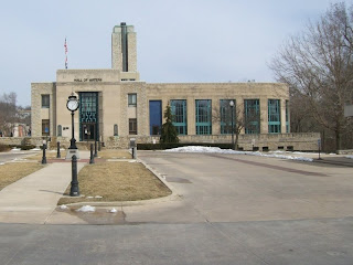
The Hall of Waters
In 1935, the city of Excelsior Springs purchased the rights to 10 springs and in the same year, ground was broken to start a $1 million Public Works Administration project m downtown - the Hall of Waters.
-
This is the Hall of Water . . . What! . . . No taps? . . . I was expecting to fill up my 100oz camel back with some of that high quality H20. DENIED!

-
The next stop is Wood Heights. Any questions why they call it Wood Heights? If you think that the top of that hill is where it stops, you will be sorely mistaken because that is where it just levels off for a bit, then there is a climb about ½ that to Wood Heights.
Mile 63
Excelsior Springs, (Pop: 10,847)
-
Most people when they hear Excelsior springs, think The Elms Hotel . rather than me going and re-inventing the wheel just click the link. If you think have not heard of this place, you’ll surprised you might have. This place has a lot of history.
-
Excelsior is a great place to explore. There are a lot of things to see here, I was planning on doing a lot of that, but I’m way behind schedule. Maybe you can pick up my slack.
-
The Hall of Waters
In 1935, the city of Excelsior Springs purchased the rights to 10 springs and in the same year, ground was broken to start a $1 million Public Works Administration project m downtown - the Hall of Waters.

-
This is the Hall of Water . . . What! . . . No taps? . . . I was expecting to fill up my 100oz camel back with some of that high quality H20. DENIED!

-
The next stop is Wood Heights. Any questions why they call it Wood Heights? If you think that the top of that hill is where it stops, you will be sorely mistaken because that is where it just levels off for a bit, then there is a climb about ½ that to Wood Heights.

-
Mile 64
Wood Heights, (Pop 742)

 -
-

According to the Folk lore I can find on the internets; "There is an old abandon house that is out on an old road. When you pull up you get a sense of chills and shivers. This is the place where the KKK used to hang the African Americans that they tortured. When you walk up to the house you sometimes hear sounds and see things in the house like clothes on a line hanging there."
http://www.showmeparanormal.net/Haunted_Missouri.html
I know where one abandoned house is. Unless you know where to look, you will not begin to look for it. I know where it’s at because my grand father used to go around with his metal detector looking for stuff all over. At least it was a house back then, now it’s just a brush covered foundation.
-
-
Here’s our barn. I remember it being a lot taller, but maybe it wasn’t

-

Some examples of the typical buildings in Orrick.


-
Mile 81
Pigg’s Landing
PIGGSVILLE - This little community was on the bank of Fishing River at the crossing of the Missouri City road 3 miles west of Orrick on Highway 210 and was named in honor of Jefferson Pigg. Known mostly as Pigg's Landing, a house built there in 1870 by Lewis Pigg has been occupied continuously by the same family and its descendants for over a century. {Extracts from an article written by Virginia King McBee "Gone But Not Entirely Forgotten"}
-
Highlights: This grassland area offers access to the Fishing River. It has a boat ramp. . . . Grass and a boat ramp! I decided not to stop and take pictures, I’ll let your imaginations run wild.
Mile 64
Wood Heights, (Pop 742)
-
Mile 68
New garden
-
I can’t any information on New garden, but I know I find their Church’s sign a little puzzling. It’s the "Old-New-Primitive" thing
Mile 68
New garden
-
I can’t any information on New garden, but I know I find their Church’s sign a little puzzling. It’s the "Old-New-Primitive" thing

-
Mile 70
Wolf Hollow
I used to live on this 16 acre farm, we moved from here in the fall of 1976. This is the view from Wolf Hollow.
Mile 70
Wolf Hollow
I used to live on this 16 acre farm, we moved from here in the fall of 1976. This is the view from Wolf Hollow.

Wolf Hollow if a tight twisty country gravel road. I remember the school bus used to take this route to School (Orrick) and on some bad weather day would almost come to a grinding halt. Crusty you’d love it. Here’s a little taste

According to the Folk lore I can find on the internets; "There is an old abandon house that is out on an old road. When you pull up you get a sense of chills and shivers. This is the place where the KKK used to hang the African Americans that they tortured. When you walk up to the house you sometimes hear sounds and see things in the house like clothes on a line hanging there."
http://www.showmeparanormal.net/Haunted_Missouri.html
I know where one abandoned house is. Unless you know where to look, you will not begin to look for it. I know where it’s at because my grand father used to go around with his metal detector looking for stuff all over. At least it was a house back then, now it’s just a brush covered foundation.
-
Here’s the front of the house . . . Like that needed explanation.
Here’s the front of the house . . . Like that needed explanation.

-
Here is where I learned how to ride a bicycle. . . not in the road, over to the left in the grass going the full length of the field.

-
Here’s our barn. I remember it being a lot taller, but maybe it wasn’t

-
This is a bridge that begs a lot of questions.

Notice the Bridge was caught on fire at some time.

Some questions might be
1. Why was it so important to put a bridge of this size here?

Notice the Bridge was caught on fire at some time.

Some questions might be
1. Why was it so important to put a bridge of this size here?
2. Analogous to the first question, why can they do without it now
3. Who set fire to the bridge?
4. How did they put a fire of that size out, when this bridge is a couple miles away from anything?
-
Mile 77
Albany, Pop: 0
Now time is becoming an issue (4:40pm), I decided to skip Albany. The route there is a cold wet out of the way gravel road, maybe I’ll visit it another time. However it is connected . . . literally . . . with the next city
Albany - Ely Carter established the village of Albany in 1854. It was located one mile northeast of Orrick. It had seven business houses, one school, one four mill, and one church. Once Orrick grew along the railroad and the Albany stores and churches gradually moved a mile south to the new town. {Extracts from an article written by Virginia King McBee "Gone but not entirely forgotten"}
-
Albany was where Bloody Bill Anderson was killed during the American Civil War.
-
"Bloody Bill"
William T. Anderson a.k.a "Bloody Bill" (born 1839 – died October 26, 1864) was a pro-Confederate guerrilla leader in the American Civil War, known for his brutality towards Union soldiers, Jayhawkers, and pro-Union civilians in Missouri and Kansas.
-
Orrick, (Pop 889)
Orrick is a city in Ray County, Missouri, United States. The population was 889 at the 2000 census.
Orrick now includes what was once the village of Albany (there is another Missouri community called Albany, Missouri
-
Where does the name Orrick come from? It is a strange name. The Orrick Surname is a habitational taken on from the place name orrock in Fife. Spelling variations of this family name include: Horrock, Horocks, Orrocks, Orrocks, Orrox, Horrox and others.
First found in Fifeshire in southeastern Scotland.
Some of the first settlers of this family name or some of it's variants were found back as far as 1635.

-
Mile 77
Albany, Pop: 0
Now time is becoming an issue (4:40pm), I decided to skip Albany. The route there is a cold wet out of the way gravel road, maybe I’ll visit it another time. However it is connected . . . literally . . . with the next city
Albany - Ely Carter established the village of Albany in 1854. It was located one mile northeast of Orrick. It had seven business houses, one school, one four mill, and one church. Once Orrick grew along the railroad and the Albany stores and churches gradually moved a mile south to the new town. {Extracts from an article written by Virginia King McBee "Gone but not entirely forgotten"}
-
Albany was where Bloody Bill Anderson was killed during the American Civil War.
-
"Bloody Bill"
William T. Anderson a.k.a "Bloody Bill" (born 1839 – died October 26, 1864) was a pro-Confederate guerrilla leader in the American Civil War, known for his brutality towards Union soldiers, Jayhawkers, and pro-Union civilians in Missouri and Kansas.
-
Orrick, (Pop 889)
Orrick is a city in Ray County, Missouri, United States. The population was 889 at the 2000 census.
Orrick now includes what was once the village of Albany (there is another Missouri community called Albany, Missouri
-
Where does the name Orrick come from? It is a strange name. The Orrick Surname is a habitational taken on from the place name orrock in Fife. Spelling variations of this family name include: Horrock, Horocks, Orrocks, Orrocks, Orrox, Horrox and others.
First found in Fifeshire in southeastern Scotland.
Some of the first settlers of this family name or some of it's variants were found back as far as 1635.

The Wabash Railroad had chosen the site for their new passenger station. The 8.7mile Wabash line opened on Nov. 7, 1927 connecting Excelsior Springs directly to St. Louis, Buffalo, and New York City. The new line quickly became important to both incoming tourists and local.T he building's life as a railroad station was short-lived. By 1933, highways were efficient enough to draw riders away from the train.The building housed two local family-owned businesses in the years to 1996, when the building was vacated and put up for sale. Two life-time Excelsior Springs residents saw the depot and visualized a longtime dream — to operate a restaurant.
-
The Wabash Railroad was a Class I railroad that operated in the mid-central United States. The Wabash's major freight traffic advantage was the direct line from Kansas City to Detroit, without going through St. Louis or Chicago. The name Wabash Railroad or Wabash Railway may refer to various corporate entities formed over the years using one or the other of these two names until the name disappeared in 1964 when the Norfolk and Western Railway leased the Wabash System.
-
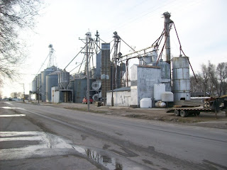
This is where we used to pick up the feed for our cattle
This is where we used to pick up the feed for our cattle

Some examples of the typical buildings in Orrick.


-
Mile 81
Pigg’s Landing
PIGGSVILLE - This little community was on the bank of Fishing River at the crossing of the Missouri City road 3 miles west of Orrick on Highway 210 and was named in honor of Jefferson Pigg. Known mostly as Pigg's Landing, a house built there in 1870 by Lewis Pigg has been occupied continuously by the same family and its descendants for over a century. {Extracts from an article written by Virginia King McBee "Gone But Not Entirely Forgotten"}
-
Highlights: This grassland area offers access to the Fishing River. It has a boat ramp. . . . Grass and a boat ramp! I decided not to stop and take pictures, I’ll let your imaginations run wild.
-
Mile 88
Missouri City, Pop: 295 /Atchison/Williams Landing/ St. Bernard/ Richfield/ ???
Is Missouri City a city with an identity crisis? This city’s name should be "Dodge and Weave" with all it’s name changes and associations. Back in the late 80’s we had a monthly time trail that went From Liberty to Missouri City and back. We referred to Missouri City as a bump in the road. Who knew its significance?
-
This is what it used to look like.

this is what it looks like now.


-

-

-
1807 – 1820 (Atchison)
Missouri City was originally named Atchison. The earliest known use of the name was on a deed to a building from 1820. The land was possessed by French fur traders Antoine Laffond and Bernard Laffond as early as January 24, 1807.
-
1834 (Williams' Landing)
The origin of the town of Missouri City was the establishment, at the mouth of Rose's branch, about 1834, of what was called Williams' Landing. In the year 1840 Eli Casey brought a stock of goods to Williams' Landing and opened a small store.
-
1844 (Williams' Landing/ St. Bernard)
In about 1844 the shipping current of the Missouri began the formation of a bar in front of Old Richfield, interfering with and preventing the landing of steam boats, and a joint stock company...laid out a town just below, but mainly on top of a high bluff overlooking the Missouri, which they called St. Bernard...The company erected a large two-story hotel on top of the bluff...Afterwards John S. Houston sold goods in this house, and was the first postmaster. The post-office was called St. Bernard.
-
1846 (Williams' Landing/ St. Bernard /Richfield)
In 1846 there were about a dozen houses at the mouth of the branch, include James Riggs' hotel, and the place was called Richfield.
1846 – 1859 (Atchison)
Just below and adjoining St. Bernard was a tract of land which had been entered in the name of Abram Fry. After several transactions, another town was laid out which was called Richfield.1 Then Thos. Williams, a son of Shrewbury Williams, bought a tract of land of his father just east of Richfield, and laid out a village he called Atchison, in honor of Ho. D. R. Atchison
-
1859 - Present
March 14, 1859, the three towns of St. Bernard, Richfield and Atchison were incorporated by the Legislature as one and called it Missouri City
-
David Rice Atchison (President of the United States for one day—Sunday, March 4, 1849)
David Rice Atchison (August 11, 1807 – January 26, 1886) was a mid-19th century Democratic United States Senator from Missouri. He served as President pro tempore of the United States Senate for six years. He is probably best known for the one day (March 4, 1849) that some have suggested he was President of the United States.
http://en.wikipedia.org/wiki/David_Rice_Atchison-

Mile 88
Missouri City, Pop: 295 /Atchison/Williams Landing/ St. Bernard/ Richfield/ ???
Is Missouri City a city with an identity crisis? This city’s name should be "Dodge and Weave" with all it’s name changes and associations. Back in the late 80’s we had a monthly time trail that went From Liberty to Missouri City and back. We referred to Missouri City as a bump in the road. Who knew its significance?
-
This is what it used to look like.

this is what it looks like now.


Still in Missouri City and look at where the sun is.

This is the last City , so now let the race against the sun begin.

-
1807 – 1820 (Atchison)
Missouri City was originally named Atchison. The earliest known use of the name was on a deed to a building from 1820. The land was possessed by French fur traders Antoine Laffond and Bernard Laffond as early as January 24, 1807.
-
1834 (Williams' Landing)
The origin of the town of Missouri City was the establishment, at the mouth of Rose's branch, about 1834, of what was called Williams' Landing. In the year 1840 Eli Casey brought a stock of goods to Williams' Landing and opened a small store.
-
1844 (Williams' Landing/ St. Bernard)
In about 1844 the shipping current of the Missouri began the formation of a bar in front of Old Richfield, interfering with and preventing the landing of steam boats, and a joint stock company...laid out a town just below, but mainly on top of a high bluff overlooking the Missouri, which they called St. Bernard...The company erected a large two-story hotel on top of the bluff...Afterwards John S. Houston sold goods in this house, and was the first postmaster. The post-office was called St. Bernard.
-
1846 (Williams' Landing/ St. Bernard /Richfield)
In 1846 there were about a dozen houses at the mouth of the branch, include James Riggs' hotel, and the place was called Richfield.
1846 – 1859 (Atchison)
Just below and adjoining St. Bernard was a tract of land which had been entered in the name of Abram Fry. After several transactions, another town was laid out which was called Richfield.1 Then Thos. Williams, a son of Shrewbury Williams, bought a tract of land of his father just east of Richfield, and laid out a village he called Atchison, in honor of Ho. D. R. Atchison
-
1859 - Present
March 14, 1859, the three towns of St. Bernard, Richfield and Atchison were incorporated by the Legislature as one and called it Missouri City
-
David Rice Atchison (President of the United States for one day—Sunday, March 4, 1849)
David Rice Atchison (August 11, 1807 – January 26, 1886) was a mid-19th century Democratic United States Senator from Missouri. He served as President pro tempore of the United States Senate for six years. He is probably best known for the one day (March 4, 1849) that some have suggested he was President of the United States.
http://en.wikipedia.org/wiki/David_Rice_Atchison-
-
Mile 93
Route 210

-
Mile 98
Liberty Bend
I have lost my race against the sun. Who knew 110 Miles would take 11 hours. I guess when you ride it sight seeing all day it will get away from you. Let’s just say I’m not very illuminated right now wearing all black.

Liberty Bend
I have lost my race against the sun. Who knew 110 Miles would take 11 hours. I guess when you ride it sight seeing all day it will get away from you. Let’s just say I’m not very illuminated right now wearing all black.

-
Mile 100
Sugar Creek
Take call from Crusty . . .
Crusty: "So how was the ride:"
Curb: "I’m still Riding."
Crusty: "What? . . WTF"
Curb: "Yep!"
Sugar Creek
Take call from Crusty . . .
Crusty: "So how was the ride:"
Curb: "I’m still Riding."
Crusty: "What? . . WTF"
Curb: "Yep!"
-
Mile 105
Independence
Called it a day at Minsky’s on 291 http://www.minskys.com/. It’s not good being invisible in traffic at night, and they have my favorite pizza here. After 11-1/2 hours 105 miles I could use a pizza.
Mile 105
Independence
Called it a day at Minsky’s on 291 http://www.minskys.com/. It’s not good being invisible in traffic at night, and they have my favorite pizza here. After 11-1/2 hours 105 miles I could use a pizza.
Subscribe to:
Posts (Atom)